I hope everyone has enjoyed this blog for the 2009-2010 season. This blog is going on hiatus until ISSW 2010, during which I will begin posting again.
Please have a happy, fun, and safe spring touring season.
Best,
Mike
Technical information, news, research, and opinion on avalanches, snow safety, and winter backcountry travel.
Monday, April 12, 2010
Sunday, April 4, 2010
Trip Planning
Mistakes have been made that left me crashing through the ice—Casey Stratton
NOTE: This post contains an entirely non-commercial, completely unsponsored link to Amazon.com.
One important difference between professional guides and recreational skiers is the level of planning that goes into each tour. Professional guides are usually well-versed in the snowpack history for the current winter, and have access to a lot more information than the average backcountry skier.
Touring during high avalanche danger is a complex risk-management problem that requires professional conduct, including planning and excellent judgment. Diligent planning can raise awareness and help minimise uncertainty before you even hit the backcountry.
How can you manage the risks?
Remember, the fastest way to find yourself in the middle of a disaster is to travel somewhere you don't belong. So, with that in mind, it's best to start small ... very small.
Why Plan?
Planning is a great way to stay alive on backcountry outings that take place during high avalanche danger. The best ski days usually take place during high avalanche danger, so having a good plan enables you to make optimal terrain and slope choices. It's a bit heretical to suggest that backcountry skiers can ski safely during high avalanche danger, but it is possible. It is definitely not a good idea to go backcountry skiing during high avalanche danger if you can't be bothered to spend a few hours planning. In other words, if you're not willing to plan, then don't go touring during high avalanche danger because, as a danger to others, you simply don't belong in the backcountry.
At the recreational level, planning for a day tour often involves little more than selecting an appropriate area and finding a trailhead. It's really quite easy if you have prior experience in the terrain, or if you are comfortable playing by ear. With some education, experience, and common sense, using an informal process is probably safe on days when avalanche danger is low or moderate.
Touring during high avalanche danger is only possible with flawless route finding, careful slope selection, and an accurate assessment of current instability. For example, conventional wisdom says that you should avoid touring in avalanche terrain during high danger, or you should stick to the trees. The only problem is that avoiding travel in avalanche terrain during high danger is fundamentally incompatible with how most ski touring takes place, and the trees are a terrible place to be during an avalanche.
Heliotrope Ridge
I recently went on a trip to Heliotrope Ridge, and having never been there before, I actually planned the trip because I had no experience with the area. For those who are unfamiliar with Heliotrope Ridge, it's a fantastic area with incredibly beautiful, fun terrain. One of my partners discussed heading up Grouse Creek, so I decided to examine the terrain using a contour map of the area made available at Google Maps. This is a great resource because the shaded view makes it much easier to read the terrain than a standard contour map. On the other hand, it's not nearly as detailed as a Natural Resources Canada quadrangle or USGS quad, so keep that in mind.
Avalanche Characteristics Of The Terrain
Figure 1.1. Heliotrope Ridge Contour Map. Grouse Creek is clearly shown in the left side of the image.
This means that our route of ascent, which included travel through an obvious terrain trap / line-of-flow was somewhat protected from the large starting zone above the gully. When I say line-of-flow, I am referring to the fact that a channel such as a gully is a location where you expect to find very fast moving avalanches. Why analyse terrain for large, natural avalanches? Well, natural avalanches are a concern if you're touring during high avalanche danger. So, examine the contour map, and satellite imagery, and start thinking like an avalanche. Where would you start? Where would you flow? What would you hit on the way down? Where would you stop?
Figure 1.1. Heliotrope Ridge Contour Map. This provides a view of the terrain contours with helpful shading.

Figure 1.2. Heliotrope Ridge Satellite Map. The aerial imagery option provides additional details.

Analysis:
In any case, there hadn't been enough recent precipitation for large, dry avalanches, so I wasn't particularly concerned. On the other hand, large accumulations of precipitation at the start of the tour, evidenced by deep ski penetration for example, would have been an immediate red flag. I probably would have turned around or found another way up.
The Trip Plan
After an hour or two, I had a pretty good idea of the character of the trip. We planned to approach through obstacle-filled terrain from the bottom, and there was a lot of overhead avalanche terrain, with many limitations to line-of-sight. ( Does this sound like good judgment to you? ) In this case, a lot of precipitation would be an immediate red flag. I didn't plan an alternate route, but knew that one existed up through the thick trees between our planned ascent route and our planned descent routes.
Details, Details, Details
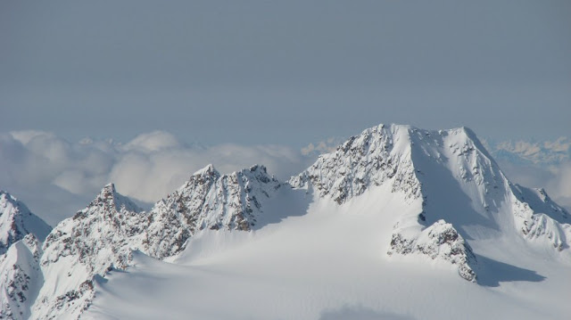
After a few hours of climbing, we arrived at the top and took in the scenery. We then decided to take a 1500 foot run down the clean, safe part of the snowfield. Conditions were great, almost boot-top powder and nearly zero instability. ( A mix of fresh crystals on top of decomposing and fragmented crystals. ) At the bottom of our first run we discussed heading up for another, and began the ascent. During the skin up, a layer of clouds came in and the temperature rose. We discussed conditions during lunch at the ridge. Everyone agreed that stability was good up high, but that the temperatures were becoming a source of concern, and freezing levels were rising. Plus, we were greeted with this view as we stared into the valley:

Ski quality up high was excellent, but after the first run, I was concerned about the layer of clouds. More specifically, I was concerned about the ragged border where the clouds met the mountains. This type of border allows sunlight in, but the thin clouds create a greenhouse effect that prevents cooling. In short, avalanche danger at the region where the clouds met the mountains was almost certainly going to be high. We knew the snowpack ( 6-10 inches of new ) was unconsolidated and unbonded to the old snow below. The small snow depths meant that skier-triggered avalanches were not likely to be dangerous, but we were prepared for instability during the descent. And as it turns out...just below the clouds...

A member of our party triggered a small, thin soft slab avalanche. A bit bigger than Size 1, but probably not enough to bury, injure, or kill a skier. Avalanches are often easily triggered during the process of consolidation, especially if consolidation is very rapid. ( Snow doesn't like rapid change. ) In this case, the snow that avalanched had been powder only hours before. The snow quickly turned to rubbery cement as we descended through the clouds, providing conclusive evidence that the sun was working its magic.
I've worked extremely hard to avoid surprises, and it felt good to issue an accurate avalanche forecast that helped us avoid a nasty surprise. Since I was surprised and partially buried by a similar avalanche in 2008, I'm going to use this avalanche as a reminder that A. ) Education works, B. ) Planning works, and C.) I need to keep learning so I can keep turning.
Notes
DO NOT tour during high avalanche danger if you feel that this level of planning exceeds your knowledge or experience.
Professional-level planning and travel techniques include the following:
Photos
Here are some photos from the trip.


 Further Reading
NOTE: This post contains an entirely non-commercial, completely unsponsored link to Amazon.com.
One important difference between professional guides and recreational skiers is the level of planning that goes into each tour. Professional guides are usually well-versed in the snowpack history for the current winter, and have access to a lot more information than the average backcountry skier.
Touring during high avalanche danger is a complex risk-management problem that requires professional conduct, including planning and excellent judgment. Diligent planning can raise awareness and help minimise uncertainty before you even hit the backcountry.
How can you manage the risks?
Remember, the fastest way to find yourself in the middle of a disaster is to travel somewhere you don't belong. So, with that in mind, it's best to start small ... very small.
Why Plan?
Planning is a great way to stay alive on backcountry outings that take place during high avalanche danger. The best ski days usually take place during high avalanche danger, so having a good plan enables you to make optimal terrain and slope choices. It's a bit heretical to suggest that backcountry skiers can ski safely during high avalanche danger, but it is possible. It is definitely not a good idea to go backcountry skiing during high avalanche danger if you can't be bothered to spend a few hours planning. In other words, if you're not willing to plan, then don't go touring during high avalanche danger because, as a danger to others, you simply don't belong in the backcountry.
At the recreational level, planning for a day tour often involves little more than selecting an appropriate area and finding a trailhead. It's really quite easy if you have prior experience in the terrain, or if you are comfortable playing by ear. With some education, experience, and common sense, using an informal process is probably safe on days when avalanche danger is low or moderate.
Touring during high avalanche danger is only possible with flawless route finding, careful slope selection, and an accurate assessment of current instability. For example, conventional wisdom says that you should avoid touring in avalanche terrain during high danger, or you should stick to the trees. The only problem is that avoiding travel in avalanche terrain during high danger is fundamentally incompatible with how most ski touring takes place, and the trees are a terrible place to be during an avalanche.
Heliotrope Ridge
I recently went on a trip to Heliotrope Ridge, and having never been there before, I actually planned the trip because I had no experience with the area. For those who are unfamiliar with Heliotrope Ridge, it's a fantastic area with incredibly beautiful, fun terrain. One of my partners discussed heading up Grouse Creek, so I decided to examine the terrain using a contour map of the area made available at Google Maps. This is a great resource because the shaded view makes it much easier to read the terrain than a standard contour map. On the other hand, it's not nearly as detailed as a Natural Resources Canada quadrangle or USGS quad, so keep that in mind.
Avalanche Characteristics Of The Terrain
Figure 1.1. Heliotrope Ridge Contour Map. Grouse Creek is clearly shown in the left side of the image.
- Blue line indicates route of ascent.
- Red areas indicate avalanche starting zones.
- There is a small series of moraines that serve as flow retarders.
- These moraines are also capable of redirecting flow away from a steep section of our ascent route.
- These moraines would NOT provide any protection from a large, dry avalanche.
- In general, FEW options to reduce exposure along this travel route.
- Terrain is COMPLEX.
This means that our route of ascent, which included travel through an obvious terrain trap / line-of-flow was somewhat protected from the large starting zone above the gully. When I say line-of-flow, I am referring to the fact that a channel such as a gully is a location where you expect to find very fast moving avalanches. Why analyse terrain for large, natural avalanches? Well, natural avalanches are a concern if you're touring during high avalanche danger. So, examine the contour map, and satellite imagery, and start thinking like an avalanche. Where would you start? Where would you flow? What would you hit on the way down? Where would you stop?
Figure 1.1. Heliotrope Ridge Contour Map. This provides a view of the terrain contours with helpful shading.

Figure 1.2. Heliotrope Ridge Satellite Map. The aerial imagery option provides additional details.

Analysis:
- Grouse Creek is basically a large avalanche path fed by multiple starting zones.
- The path produces very large avalanches capable of tearing mature timber to the ground.
- From an aerial study, it's not easy to determine which type of avalanche caused the destruction.
- However, once we were on-site we observed:
- Chaotic distribution of destruction.
- Obvious damage high up on some trees.
- Damage in unusual places, such as UPHILL from obvious starting zones.
- This clearly showed that large dry avalanches, which can take unpredictable paths, were responsible for most of the damage.
- The powder component of a dry avalanche ( 90 mph winds laden with snow )often snaps the upper part of the tree even if the flowing core of the avalanche does not reach the trees.
- Wet avalanches tend to move much more slowly and follow the terrain.
- Wet avalanches tend to break the trees right off at the base.
- However, there were two levels of tree growth: old growth and ~10-year growth. This further convinced me that large, full-path avalanches were not frequent events.
- Areas with infrequent LARGE avalanches are almost always beset by many small avalanches over the course of a season. These small events may not leave many visible marks, but rest assured, they do occur.
- We were going to travel in terrain where Size 2 and Size 2.5 avalanches are fairly frequent.
In any case, there hadn't been enough recent precipitation for large, dry avalanches, so I wasn't particularly concerned. On the other hand, large accumulations of precipitation at the start of the tour, evidenced by deep ski penetration for example, would have been an immediate red flag. I probably would have turned around or found another way up.
The Trip Plan
After an hour or two, I had a pretty good idea of the character of the trip. We planned to approach through obstacle-filled terrain from the bottom, and there was a lot of overhead avalanche terrain, with many limitations to line-of-sight. ( Does this sound like good judgment to you? ) In this case, a lot of precipitation would be an immediate red flag. I didn't plan an alternate route, but knew that one existed up through the thick trees between our planned ascent route and our planned descent routes.
- Option A. Mt. Baker Summit. Not realistic, but it was discussed. No one really wanted
to carry an additional 20 lbs of mountaineering gear. - Option B. Coleman-Deming Saddle. We discussed this option, but upon seeing fantastic
powder conditions, and NOT having any glacier travel gear, we decided against it. - Option C. Ski Bump. We chose this option and enjoyed about 3000 vertical feet of
powder turns. - Bands. All three tours involve travel through all three elevation bands. Below-treeline, At-Treeline, and Alpine.
- Leg 1
- Start of Grouse Creek Avalanche Path 3600 ft
- Entrance of Moraine Gullies @ 4800 ft
- 1200 vertical ft
- Band: Below-Treeline
- Notes
- Travel to entrance of moraine gullies and take a left.
- This route is exposed to overhead avalanche terrain.
- This route travels through confined terrain with limited line-of-sight.
- This route is exposed to three avalanche starting zones.
- This route travels through an obstacle-filled debris accumulation zone.
- At least one of the starting zones is partially obstructed by moraines.
- The start zone at top, skier's right is very large and probably responsible for the largest avalanches.
- Leg 2
- Entrance to moraine gullies 4800 ft.
- Notch below "ski bump" @ 6400 ft.
- 1600 vertical ft.
- Band: At-Treeline, Alpine
- Notes
- Climb up and left toward notch.
- This route is exposed to overhead avalanche terrain.
- This route travels through confined terrain with limited line-of-sight.
- A series of moraine features provide some protection.
- These features can retard some flowing snow.
- These features can re-direct some flowing snow away from travel route.
- Leg 3
- Notch below "ski bump" @6400 ft
- Top of "ski bump" @7100 ft
- 700 vertical ft.
- Band: Alpine
- Notes
- Climb slightly skier's left to avoid being taken into gully in case of avalanche.
- Prospects for rescue are "simpler" on skier's left.
- Main Reason: Good line-of-sight, simple slope shapes.
- However, there are a few places with potential for deep burial.
- Avalanches don't frequently run the entire length from skier's bump to tree-line.
- If they did, the destruction would be much larger.
Details, Details, Details
After a few hours of climbing, we arrived at the top and took in the scenery. We then decided to take a 1500 foot run down the clean, safe part of the snowfield. Conditions were great, almost boot-top powder and nearly zero instability. ( A mix of fresh crystals on top of decomposing and fragmented crystals. ) At the bottom of our first run we discussed heading up for another, and began the ascent. During the skin up, a layer of clouds came in and the temperature rose. We discussed conditions during lunch at the ridge. Everyone agreed that stability was good up high, but that the temperatures were becoming a source of concern, and freezing levels were rising. Plus, we were greeted with this view as we stared into the valley:

Ski quality up high was excellent, but after the first run, I was concerned about the layer of clouds. More specifically, I was concerned about the ragged border where the clouds met the mountains. This type of border allows sunlight in, but the thin clouds create a greenhouse effect that prevents cooling. In short, avalanche danger at the region where the clouds met the mountains was almost certainly going to be high. We knew the snowpack ( 6-10 inches of new ) was unconsolidated and unbonded to the old snow below. The small snow depths meant that skier-triggered avalanches were not likely to be dangerous, but we were prepared for instability during the descent. And as it turns out...just below the clouds...

A member of our party triggered a small, thin soft slab avalanche. A bit bigger than Size 1, but probably not enough to bury, injure, or kill a skier. Avalanches are often easily triggered during the process of consolidation, especially if consolidation is very rapid. ( Snow doesn't like rapid change. ) In this case, the snow that avalanched had been powder only hours before. The snow quickly turned to rubbery cement as we descended through the clouds, providing conclusive evidence that the sun was working its magic.
I've worked extremely hard to avoid surprises, and it felt good to issue an accurate avalanche forecast that helped us avoid a nasty surprise. Since I was surprised and partially buried by a similar avalanche in 2008, I'm going to use this avalanche as a reminder that A. ) Education works, B. ) Planning works, and C.) I need to keep learning so I can keep turning.
Notes
DO NOT tour during high avalanche danger if you feel that this level of planning exceeds your knowledge or experience.
Professional-level planning and travel techniques include the following:
- Use careful planning to raise awareness and minimise uncertainty prior to the trip.
- Do not travel somewhere you don't belong.
- Do not travel in unfamiliar terrain during poor visibility.
- Evaluate party members, especially individual risk acceptance.
- Identify the characteristics of avalanches in the area.
- Find additional route options.
- Formulate a strategy to ascend safely.
- Formulate a strategy to descend safety.
- Create a table of vertical/times/distances for the chosen routes.
- Take several reconnaisance trips to the area.
- Avoid traveling below overhead avalanche terrain.
- Avoid cornices, locations suitable for rock fall, and slopes holding loose snow.
- Shortcuts kill, so go around if you don't have a heli.
- If you can't go around, go fast.
- If you can't go fast, go to a resort.
- Choose slopes where avalanche rescue is possible.
- Descend slopes without obstacles such as trees and rocks.
- Look for smooth, clean runout zones with excellent line-of-sight from the top.
- Poor line-of-sight, such as in trees or convoluted terrain, makes rescue much more difficult.
- Have an escape plan for key components of the line.
- Forget about skiing between supposed safe zones.
- There are no safe zones.
- Safe zone prediction often involves foolish assumptions about propagation.
- Choose steeper slopes with extreme care, even if the slope is small.
- Choose slopes you can ski from the top.
- Choose slopes you can ski cut safely.
- Pick your line of descent very carefully.
Photos
Here are some photos from the trip.


- The Importance Of Considering Natural Avalanches
- Although Capable, Guides Should Never Ski Alone
- Snowmobilers Raising Cash For Canadian Avalanche Centre
- The Avalanche Handbook ( You can learn how to evaluate terrain like a professional. )
Subscribe to:
Posts (Atom)