NOTE: This is the first in a series of posts that will address the general question of Why Is It So Complicated? While teaching often involves simplification, it's important to remember that you can also use complexity to teach. Despite conventional wisdom, complexity is not always the enemy of simple, and simplicity does not always improve understanding.
Introduction
Today's post is going to discuss wind loading, more specifically the ins-and-outs of using wind speed and direction to forecast wind loading. The main difficulty in using a simple model, is that the simple model doesn't account for turbulence, and turbulence has an incredible influence on the "patterns" of wind deposited snow.
Video 1. You can't see clear air turbulence, but watch this time-lapse video. The presence of clouds makes the turbulence very easy to see. At about 1 minute, you can watch some backwards loading, where turbulent vortices load a slope that is facing against the wind. This is referred to by the very technical term wind slab where you least expect it.
The public avalanche bulletin often contains a forecast of aspects on which you might expect to find wind loading, but it's important to remember that a.) the public avalanche bulletin covers a very large area, b.) avalanche forecasters have a lot of knowledge about the interaction between terrain and weather, as well as a deep body of experience about a variety of such situations in the past, and c.) they also have access to very sophisticated computer models. Forecasters with years of experience at a specific location will also develop a very good sense of how a specific storm will influence loading in certain areas.
Since most of us normal folks don't have that experience, we need to stick with the tried and true.
Character Of The Data
Wind speed and direction is Class III information, which means there is high uncertainty about its relationship to avalanche formation. High uncertainty exists because there are many ways to interpret the data, and as a result, this data may or may not reveal useful information about instability. This is because the physics behind wind flow are intensely complicated and the specific outcomes are very possibly unknowable.
Prevailing Wind
When we talk about wind, there are two important elements: the prevailing wind and local winds. The prevailing wind is located high above rough mountain terrain, where airflow is unimpeded by obstacles. We can express the prevailing wind with a direction such as north or northwest, and with a speed such as 20 knots. Broadly, the prevailing wind is influenced by horizontal pressure differences and the rotation of air around pressure centres.
An additional complication of using prevailing wind is that the varying shape and behaviour of cyclonic weather systems means that the prevailing wind speed and direction can change during the passage of a storm, and it can be difficult to predict these changes because of the dynamic nature of weather systems. The reality is that each storm is a completely unique event that is driven by a set of completely unique parameters that will never happen again. Once you start to understand the complexity, it becomes easier to understand how to use this complexity to your advantage during the process of backcountry avalanche forecasting.
As usual, this complexity provides very useful clues about what not to do.
Local Wind
Anyway, things become awfully complicated when a large storm moves over the mountains and the air starts interacting with terrain. This is referred to as local wind. Local wind is formed from a complex stew of frontal lifting, orographic lifting, convective lifting, and convergence-based lifting, in addition to frictional forces.
Picture a mountain valley, along with all its nooks, crannies, and crevices. As air moves through complex mountain terrain, it hits obstacles that cause it to become turbulent. Large features block and channel the large scale flow, while airflow over, around, and through smaller barriers generates localised turbulence. On this blog I frequently refer to the chaotic interaction between terrain and weather, and these crazy wind patterns are a very large part of the chaos. Naturally, the mere presence of chaos raises uncertainty because chaos suggests that uncertainty is the only state of affairs.
Clouds, along with other sophisticated meteorological data, can provide a fairly good visual model of this turbulence at a large scale, but these data are almost no use at the small scales required for effective backcountry avalanche forecasting. At small scales, we can use weather stations to measure local wind, but because of resource limitations, our picture of local wind speed and direction is actually extremely limited.
Thankfully, despite these problems, there are a few really good techniques that we can use to determine if wind loading has occurred. In simple terms, even though the wind is invisible, and even though the chaos of turbulence makes it very hard to determine local wind flow, we can observe the physical environment for the signals of wind loading.
Examples
What do we know about the complexity of wind speed and direction at a single location? What about the chaotic complexity of turbulence?
Figure 1.1. Wind speed and direction at 1 hour increments for Crystal Mountain "Green Valley" weather station over the course of a single day. Since the weather station measures wind on an hourly basis, there is a lot of missing data here.

Figure 1.2. Wind speed and direction at 1 hour increments for Crystal Mountain "Green Valley" weather station over the course of a single day. Here, the pattern matching software in our brains sees two broad patterns that may be associated with a major wind direction change that occurs when a cyclonic weather system passes over the weather station. Or, maybe our brains are seeing a pattern where no pattern exists.

Figure 1.3. Wind speed and direction at 1 hour increments for Crystal Mountain "Green Valley" weather station over the course of a single day. Here our brain is tempted to view "clusters" of wind directions, but even if these "clusters" do occur, our brain is simply incapable of accounting for turbulence, and these "patterns" may very well arise from turbulence and contribute to additional turbulence. It's pretty crazy, isn't it?

Figure 1.4. Complex deposition and drift patterns near the toe of the Sulphide Glacier. Can you identify the wind slab? Does the wind slab have a simple shape? Is the layering simple or complicated?


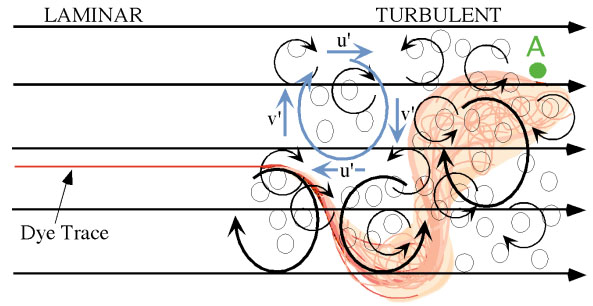
Figure 1.6. From MIT. The difference between laminar and turbulent flow. Imagine this in three dimensions, and then imagine trying to relate this model to snow deposition patterns. By now it's pretty obvious that you can't actually do this. It's worth mentioning that a supercomputer with 1024 cores might be able to produce a relatively accurate simulation. However, small inaccuracies in the input data, including inaccuracies that are immeasurably small, and/or inaccuracies in the mathematics of the simulation, will produce severe errors at every scale. This means that you'll end up with a simulation that "looks accurate", but actually has no relationship to the real world.
Conclusion
So what's a guy or gal to do? Well, given the complexity and uncertainty that arises, observations of local weather and snow deposition patterns remain the gold standard for discerning the parameters of wind loading. You can safely assume that any combination of wind and snow means that some wind loading has occurred.
- Significant amounts of snow are removed from windward slopes.
- Significant amounts of snow can be deposited on lee slopes.
- Drifting patterns. Drifts point in the same direction as airflow.
- Snow build up, or the lack thereof, on trees and rocks.
- Cornices point in the direction of airflow and indicate loading below.
- Look for ripple patterns on the snow surface.
- Observe the snow's texture, especially its hardness.
- Wind slab often sounds hollow when you step on it.
- Wind slab has an intricate shape and layering.
- Complex stratigraphy raises uncertainty.
- Delicate and/or intricate transitions between clean and dirty snow may exist.
- Given the foregoing, never try to outsmart the snowpack. It simply can't be done.
Futher reading that merely hints at the unreal complexity of the problem:
- Chaos Theory ( Wikipedia )
- Turbulence ( Wikipedia )
- Navier-Stokes Equations ( Wikipedia )
- Wind Tunnels ( Wikipedia )
No comments:
Post a Comment